Thoughts on teaching, technology, learning and life in an era of change.

Archive for the ‘ History ’ Category

Amazing Stockton Beach, NSW
January 17th, 2009

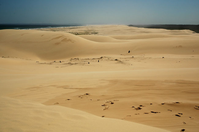
Stockton Beach sand dunes, looking south.

Earlier this week Shao Ping and I had the opportunity to explore Stockton Beach, south of Port Stephens in NSW. The sand dunes of Stockton beach stretch for 32 kilometres and in some areas reach 1 kilometre inland.


View Larger Map

We explored the dunes late one afternoon and then went on an organised tour the following day. The dunes are moving approximately 4 metres in a northerly direction each year.

Northern end of the dunes near Anna Bay.
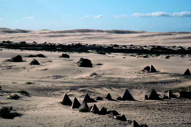
Tank traps are visible in the foreground.

The dunes feature tank traps that were constructed to deter an invasion by the Imperial Japanese Army during the Second World War.

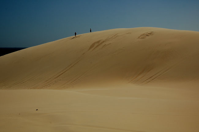
The dunes can be as high as 30 metres.

The earliest inhabitants of this region were the members of the Worimi Aboriginal tribe.  The middens created by the tribe during the previous 12,000 years can be seen at many points along the length of the beach. The middens appear and disappear with the ever shifting sands.

Tin City

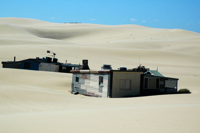
As well there is the intriguing Tin City. This is a collection of shacks that had their origins during the Great Depression. They were built and occupied by impoverished Australians. The shacks made way for an army camp during the Second World War and were rebuilt after the war. At this time four men still live in the remaining shacks. They were utilised as a set during the Mad Max movie. It is hard to believe that individuals could live in such an environment. They utilise solar and wind power as well as a groundwater supply. Keeping out the sand must be an ongoing challenge for the four inhabitants.

Guess who?

If you are ever in the Port Stephens and Newcastle region of NSW the Stockton dunes are well worth a visit. Shao Ping and I certainly had a jolly good time. I have uploaded a gallery of photographs of the dunes to my main web site.

Battle of Thermopylae 480BC
December 15th, 2008


View larger image

This is an ancient aerial photograph taken just before the final stages of the historic Battle of Thermopylae between the Greeks and the Persians in 480BC. The image was taken by Anna Chronism. The Greek forces were courageously led by Leonidas. The troops are camped by one of the ancient walls of the pass. To the right the traitor Ephialtes can be seen.

How was this post created? The original photograph was taken using a digital camera. Mt Faber, Singapore, 2003. The ants were building a wall of sorts prior to a storm on a step on a path. Were they intending to funnel water towards or away from their nest I wonder? Why were they building a wall? Was the impending storm their version of an invading Persian force? I imported the photograph into Comic Life. The cartoon elements were added. I exported the project as an image. Opened it in Photoshop Elements and saved the image for the web. Large and small.

Google Earth discoveries
November 23rd, 2008

Google Earth and its browser based cousin Google Maps fascinate. This morning I read that a possible meteorite crater has been discovered in western New South Wales. The report in the Sydney Morning Herald tells the story of opal miner Mike Fry and how he spotted the crater via Google Earth. Mr Fry had been using Google Earth to explore terrain for possible opal mining sites. The site requires further geological investigation to confirm it is the result of an meteorite impact. The western rim of the site is visible. The eastern rim has been significantly eroded and is no longer visible.


View Larger Map

Earlier this year another potential impact crater was discovered in Western Australia by Dr Arthur Hickman, a government geologist with the Geological Survey of Western Australia.


View Larger Map

If you are interested in similar discoveries and meteorite craters around the globe this Google Earth Hacks site, Craters [scroll down], and this Google Maps site, Meteor Craters may interest you.

It fascinates that both of these geological ‘discoveries’ were made whilst seated in front of a computer display.

Have you ever made a ‘discovery’ while exploring Google Earth or Google Maps. Some time back I was exploring some of the towns where my wife and I had lived while we were living in Singapore. To my surprise I ‘discovered’ that a group of trees that were located in a park that was adjacent to our estate spelt out the name of the town, Pasir Ris. We had walked through and around the park many times yet we never realised that the trees had been so planted.


View Larger Map

In the classroom I like to use Google Earth to support the teaching of history. It is particularly useful when teaching students the history of the Persian Wars. Sites for battles such as Marathon, Salamis, Thermopylae and Artemisium are all accessible. Of course the terrain and coastlines have altered to some extent yet the maps provide an invaluable viusal for the students and it makes the events all the more tangible.


View Larger Map

Battle of Marathon site. Athenian soldiers are buried in this mound.


View Larger Map

Both the Battle of Thermopylae and the naval battle of Artemisium were fought in this region.


View Larger Map

The Battle of Salamis was fought in the narrows between the island of Salamis and the coastline of ancient Attica

So, have you made any “discoveries” using Google Earth? What do you think are some of the more interesting locations visible via Google Earth? How do you use Google Earth in the classroom?

Remembrance Day
November 11th, 2008


Commonwealth War Graves, Kranji, Singapore

Today is Remembrance Day. Today many people around the world commemorated the sacrifices of soldiers and also civilians in times of war. The day marks the end of the First World War on the 11th November, 1918.


Commonwealth War Graves, Kanchanaburi, Thailand

The students at our school marked the day with a service at 11.00AM. It was at this time on the 11th November, 1918 when hostilities ceased. Myself and three students also attended a service at the Albion RSL Sub Branch Memorial Club. The service was led by Harry Spicer OAM.

The aim is not to glorify war. Simply to remember.

Pompeii and Herculaneum ~ resources and links
November 10th, 2008

Students undertaking the 2 Unit Ancient History course in the New South Wales Higher School Certificate are required to complete a compulsory study of Pompeii and Herculaneum. When they attempt the relevant section in the final examination they need to answer three questions as follows:

Question 1, which usually consists of several parts, requires the students to extract relevant information from some or all of the historical sources included with the question.
Question 2 requires the students to employ historical sources and apply their own knowledge to reconstruct aspects of life in Pompeii and Herculaneum.
Question 3 requires the students to refer to sources and apply their own knowledge to issues of investigating, reconstructing and preserving the past and related ethical issues.

My students are presently researching for a presentation on the life and society of the people of Pompeii and Herculaneum. They are permitted to use technology to faciliate their presentation. Each student has to collect a range of historical sources to augment their presentation. I hope to utilise a wiki or web site to collate all of their material.

I have updated a dedicated web site of links to research, resources and photographs of Pompeii and Herculaneum.

Links include the Soprintendenza archeologica di Pompei, The Forum at Pompeii, Mazois’ famous sketches of Pompeii, CyArk’s multimedia exploration of Pompeii, the excellent QuicktimeVR panormas created by Francesca Tronchin and Diego Bonilla, an extensive gallery of images at the University of Buffalo and John Hauser’s pictures of Pompeii. I have also added a set of links to relevant galleries on Flickr.